|
Eternal snows and indigenous
markets
The province of Cotopaxi’s main attraction is Cotopaxi National Park.
Located on the eastern plain of Patate, in the center of the country, Cotopaxi’s
climate varies from 12 to 17 degrees centigrade. In addition to Cotopaxi
National Park, the province has major indigenous markets and is rich in
popular traditions.
TOP
Towns and Villages
Latacunga, showcasing typical Spanish colonial architecture, is the capital
of Cotopaxi province. Its name comes from the indigenous words llacata
kunka, which mean God of the Lakes. Among Latacunga's interesting sights
are the Town Hall, with its pumice stone facade, and Ignacio Flores Park
with its artificial lake.
Other towns, such as Pujil?, are known primarily for their agricultural,
cattle, and handicraft production. Pujil? is famous for its painted and
glazed ceramic. Its central church is another of its riches. North of Latacunga
lies
Saquisil?, a colorful village famous for its Thursday market, which encompasses
8 blocks. Here, agricultural products and livestock are sold. This is one
of the biggest traditional markets in northern Ecuador.
Very nearby is Salcedo, which also produces an abundance of agricultural
and dairy products and is also known for its fruit and ice cream.
Tilipulo, also in the province of Cotopaxi, is famous for its St John the
Baptist Monastery, an architectural relic of the colonial era. Among its
features are beautiful cloisters, a sundial, a patio, ponds, trees, and
a cemetery.
TOP
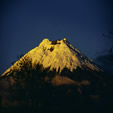
Cotopaxi National Park
This is a must-see attractions for tourists coming to Ecuador. Cotopaxi
National Park, 60 km from Quito, contains the snowcapped peak of the same
name. At 5,897 m, Cotopaxi is the world's highest active volcano. Despite
its high altitude, the park is home to a wide variety of mammals, birds,
and other endemic species. The Paramo Rabbit is one example. The park's
recreational area, El Boliche, is a lush forest with varied vegetation,
animal reserves, and campsites. Other features of the park are its lakes,
such as Limpiopungo, and its pine forests. Cotopaxi mountain has a climber's
refuge, open all year round, which can accommodate dozens of visitors.
TOP
Lake Quilotoa - A Green Eye in the Paramo
About 10 km from the village of Zumbahua, on the road to Pujilí,
there is a turnoff which takes us to Lake Quilotoa, a breathtaking lake
situated in a volcanic crater in the Chugchillán Mountain Range.
The mineralization of its turquoise waters does not allow certain species
to live there. Around the lake, mountains full of paramos and wildlife abound
on all sides. This area, near the Ilinizas volcanoes, is also popular for
mountain biking.
TOP
Culture & Traditions
The Mama Negra (Black Mama) Festival, celebrating the earth's fertility
and productivity, is one of the country's major street celebrations. It
is traditionally held in November, although there is a smaller festival
organized in September by the artisans and vendors of markets of La Merced
and Del Salto. Other well known celebrations are the traditional dances
of Salcedo, Saquisil?, Pujil?, and Latacunga, performed during the Carnival
and Corpus Christi festivities.
TOP
Cuisine
Chugchucaras is the region's typical dish. The dish, typically served
in gigantic portions, consists of fried pork, pork rinds, white corn, miniature
empenadas(pastries filled with meat and cheese), fried plantain,
corn on the cob, and popcorn. The drinks that traditionally accompanies
this delicious dish are chicha (maize-based alcoholic drink) and
beer. Other local specialities are allullas (a kind of biscuit) with
fresh cheese wrapped in a leaf, white-corn porridge, and corn flour porridge
with cherries.
TOP
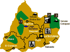
 Map of Cotopaxi, Ecuador
 |
|
|
 |
Province's Capital |
 |
Road |
 |
Cities |
 |
Hiking |
 |
Ethnic Group |
 |
Handicrafts |
 |
Cotopaxi |
 |
Ilinizas |
 |
El Boliche |
|
|