|
|
 Ecuadorian
Coast > Provinces Ecuadorian
Coast > Provinces |
|
 Ecuadorian Coast Provinces
 |
|
|
| Distances |
| Esmeraldas - Quito |
318 km |
| Portoviejo - Quito |
355 km |
| Guayaquil - Quito |
420 km |
| Babahoyo - Quito |
340 km |
| Machala - Quito |
518 km |
|
TOP
TOP
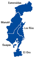
 GUAYAS
 |
 More
About Guayas, Ecuador More
About Guayas, Ecuador |
 Probably
the most economically active province of Ecuador, the province of
Guayas, in southwestern Ecuador, is home to the country's main port,
Guayaquil, and also to many important ecological reserves, such as
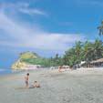
Manglares-Churute. There are seaside resorts with plenty of hotels
to choose from and small beaches where you can partake in a variety
of sports. The province has an international airport and a well-developed
infrastructure for holding national and international events. Several
international hotel chains have branches in Guayaquil. With a humid,
tropical climate, the temperature stays at around 25 degrees centrigrade
throughout the year.various sports. The province has an international
airport and infrastructure for holding national and international
events. Several hotel chains have branches in Guayaquil. The temperature
stays at around 25 degrees centigrade, while the climate is tropical
and humid. |
TOP
TOP
TOP
|
|